Extreme Weather Across the Caribbean and Southeastern United States! Flooding, Dust, and Developing Storm Systems
In early March 2026, the Caribbean and the southeastern United States are facing an unusual convergence of environmental challenges. A combination of seismic activity, widespread flooding, a large Saharan dust plume, and developing tropical systems has created a complex situation for millions of residents across the region. Together, these overlapping events highlight how unpredictable natural hazards can become when multiple threats occur at the same time.
The first concern emerged with an earthquake detected near Trinidad. Although the tremor did not cause catastrophic damage, it was widely felt and served as a reminder of the region’s underlying seismic risks. For communities already dealing with other weather-related threats, the quake added another layer of anxiety and forced emergency services to remain on heightened alert.
At the same time, Central America has been dealing with persistent heavy rainfall. Rivers have overflowed their banks in several areas, flooding homes and roads while damaging bridges and infrastructure. In mountainous regions, saturated soil has increased the likelihood of landslides, placing rural communities at additional risk and complicating rescue efforts.
Another unusual factor affecting the region is the arrival of a massive plume of Saharan dust crossing the Atlantic Ocean. Known as the Saharan Air Layer, this phenomenon often brings hazy skies and reduced air quality across the Caribbean. While the dust can sometimes slow the formation of tropical storms by stabilizing the atmosphere, it also carries fine particles that may worsen respiratory conditions for people with asthma or other breathing problems. Health officials across several islands have urged residents to limit outdoor exposure when dust concentrations are high.
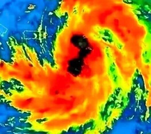
Meanwhile, meteorologists are closely monitoring developing weather systems in the Atlantic basin. Warm ocean temperatures have created favorable conditions for tropical storm development. One system in particular, Tropical Storm Flossie, has drawn attention as forecasters analyze its path and intensity.
Emergency management agencies in coastal areas of the southeastern United States, including Florida and the Carolinas, are reviewing preparedness plans in case the storm strengthens or changes direction. Officials are evaluating evacuation routes, emergency shelters, and communication systems to ensure communities are ready if severe weather approaches.
The overlapping nature of these events highlights the concept of “cascading risk.” When multiple hazards occur simultaneously—such as flooding, dust storms, earthquakes, and tropical weather—the pressure on infrastructure and emergency services increases significantly. Flooded roads can slow evacuation efforts, while health systems must respond to both storm-related injuries and respiratory issues caused by dust.
In many places, local communities have stepped in to support one another. Volunteers, fishermen, and community organizations have helped transport supplies, rescue stranded residents, and provide temporary shelter for those displaced by flooding. These grassroots efforts often play an essential role when official resources are stretched.
Modern forecasting tools provide an important advantage during complex situations like this. Satellite imagery, ocean monitoring systems, and advanced weather models allow scientists to track storms, monitor dust movement, and identify emerging risks more accurately than ever before. Even so, weather patterns can shift quickly, and conditions can change with little warning.
Officials continue to urge residents to rely on trusted sources of information rather than rumors circulating on social media. Accurate updates from meteorological agencies and emergency management offices remain the most reliable way for communities to stay informed.
Preparedness remains the most effective protection against natural hazards. Authorities recommend that families maintain emergency kits with drinking water, medications, important documents, and basic supplies in case evacuations or power outages occur.
Although the current situation reflects a challenging moment for the region, it also demonstrates the resilience of communities that have long experience adapting to changing environmental conditions. Cooperation between governments, scientists, and local residents will play a crucial role in navigating the days ahead.
While it remains uncertain how these overlapping hazards will evolve, continued monitoring and preparation provide the best chance of minimizing their impact. With careful planning and reliable information, communities across the Caribbean and the southeastern United States can face this period of environmental instability with greater confidence and readiness.